Lake Isabelle, Long Lake, and Brainard Lake Loop in Indian Peaks Wilderness
The Lake Isabelle, Long Lake, and Brainard Lake Loop in Colorado's Indian Peaks Wilderness offers hikers a journey through diverse landscapes, including wildflower meadows, subalpine forests, and mountain vistas. Along the trail, one can observe Long Lake and Lake Isabelle, both set against a backdrop of rugged mountain peaks like Apache Peak and Navajo Peak. The trail also provides panoramic vistas of Niwot Ridge and the expansive Isabelle Glacier. Wildlife sightings, such as moose, are common, adding to the trail's appeal. #Hiking #Mountain #Forest #Nature #Lake
- Distance: 10.1 Km
- Elevation gain: 238 m
- Maximum elevation: 3,339 m
- Elevation loss: 238 m
- Minimum elevation: 3,154 m
- Moving time: 2 h 43 m
- Moving speed: 3.7 Km/h
- Maximum speed: 5.8 Km/h
- Total time: 3 h 16 m
- Global speed: 3.1 Km/h
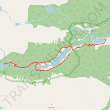
Interactive trail map
Trail profile
- Distance: 10.1 Km
- Elevation gain: 238 m
- Maximum elevation: 3,339 m
- Elevation loss: 238 m
- Minimum elevation: 3,154 m
- Moving time: 2 h 43 m
- Moving speed: 3.7 Km/h
- Maximum speed: 5.8 Km/h
- Total time: 3 h 16 m
- Global speed: 3.1 Km/h
About this trail
Name: Lake Isabelle, Long Lake, and Brainard Lake Loop in Indian Peaks Wilderness trail, distance, elevation, map, profile, GPS track
Start: Brainard Lake Road, Boulder County, Colorado, United States (40.07827 -105.57235)
End: Brainard Lake Road, Boulder County, Colorado, United States (40.07832 -105.57242)
Coordinates: 40.06785 -105.61635 40.07832 -105.57235
Other hiking, mountain biking, running and outdoor activity trails
Click on a trail to view its statistics, map and profile.
Lone Eagle Peak - Pawnee Pass
United States > Colorado > Grand County
From the Lake Granby side, this traverse begins near Monarch Lake and follows the Cascade Creek corridor into the Indian Peaks Wilderness, passing forested shoreline, Arapaho Pass Trail junction, Buchanan Creek, Cascade Creek, and waterfall-lined sections of the valley. Beyond the Cascade Creek basin, the…
Distance: 32.9 Km • Elevation gain: 2,006 m • Maximum elevation: 3,824 m