Thank you for supporting this site ❤️
Make a donation
Make a donation
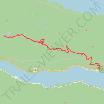
Fresien Lake Alpine Ride (Mini Whipsaw)
Supposedly the hardest 4x4 track on Vancouver Island. Much easier on an enduro. Maximum elevation of just over 1300m, putting this track into alpine territory.
- Distance: 35.2 Km
- Elevation gain: 1,779 m
- Maximum elevation: 1,301 m
- Elevation loss: 1,779 m
- Minimum elevation: 55 m
Interactive trail map
Thank you for supporting this site ❤️
Make a donation
Make a donation
Trail profile
- Distance: 35.2 Km
- Elevation gain: 1,779 m
- Maximum elevation: 1,301 m
- Elevation loss: 1,779 m
- Minimum elevation: 55 m
Thank you for supporting this site ❤️
Make a donation
Make a donation
About this trail
Name: Fresien Lake Alpine Ride (Mini Whipsaw) trail, distance, elevation, map, profile, GPS track
Coordinates: 49.27956 -125.19729 49.30995 -125.06887
Thank you for supporting this site ❤️
Make a donation
Make a donation
Other hiking, mountain biking, running and outdoor activity trails
Click on a trail to view its statistics, map and profile.
Pacific Rim National Park - Fanny Bay
Canada > British Columbia > Alberni-Clayoquot Regional District > Area C (Long Beach)
Vancouver Island. #Bike #PacificRim #Vancouver #Pacific
Distance: 93.7 Km • Elevation gain: 1,359 m • Maximum elevation: 257 m