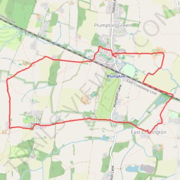
Plumpton Green, Streat and East Chiltington loop walk
- Distance: 8.5 Km
- Elevation gain: 72 m
- Maximum elevation: 72 m
- Elevation loss: 72 m
- Minimum elevation: 27 m
- Moving time: 1 h 51 m
- Moving speed: 4.5 Km/h
- Maximum speed: 7.1 Km/h
- Total time: 2 h 20 m
- Global speed: 3.6 Km/h
Interactive trail map
Trail profile
- Distance: 8.5 Km
- Elevation gain: 72 m
- Maximum elevation: 72 m
- Elevation loss: 72 m
- Minimum elevation: 27 m
- Moving time: 1 h 51 m
- Moving speed: 4.5 Km/h
- Maximum speed: 7.1 Km/h
- Total time: 2 h 20 m
- Global speed: 3.6 Km/h
About this trail
Name: Plumpton Green, Streat and East Chiltington loop walk trail, distance, elevation, map, profile, GPS track
Coordinates: 50.91937 -0.08515 50.93208 -0.04649
Other hiking, mountain biking, running and outdoor activity trails
Click on a trail to view its statistics, map and profile.
Loop walk between Ditchling Common and Plumpton Green
United Kingdom > England > East Sussex > Lewes > Ditchling Common
Distance: 18.5 Km • Elevation gain: 188 m • Maximum elevation: 76 m