Camel's Hump Loop via Forest City Trail, Long Trail and Burrows Trail
The Camel’s Hump Loop offers hikers a rewarding climb through dense forests, rugged alpine terrain, and open summit views. Starting on the Forest City Trail, hikers pass remnants of a Civilian Conservation Corps camp before joining the Long Trail, where views open up to showcase Vermont’s high peaks, the Adirondacks, and the White Mountains. After enjoying the expansive panorama from Camel's Hump’s summit, the Burrows Trail leads down through serene woodlands, completing a scenic loop that's both challenging and memorable for any outdoor enthusiast. #Hiking #Loop #Mountain #Overlook #Forest #Nature
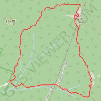
- Distance: 8.9 Km
- Elevation gain: 699 m
- Maximum elevation: 1,223 m
- Elevation loss: 701 m
- Minimum elevation: 535 m
- Moving time: 2 h 47 m
- Moving speed: 3.2 Km/h
- Maximum speed: 9.8 Km/h
- Total time: 3 h 7 m
- Global speed: 2.9 Km/h
Interactive trail map
Trail profile
- Distance: 8.9 Km
- Elevation gain: 699 m
- Maximum elevation: 1,223 m
- Elevation loss: 701 m
- Minimum elevation: 535 m
- Moving time: 2 h 47 m
- Moving speed: 3.2 Km/h
- Maximum speed: 9.8 Km/h
- Total time: 3 h 7 m
- Global speed: 2.9 Km/h
About this trail
Name: Camel's Hump Loop via Forest City Trail, Long Trail and Burrows Trail trail, distance, elevation, map, profile, GPS track
Start: Camel's Hump Road, Huntington, Chittenden County, Vermont, United States (44.30494 -72.90787)
End: Camel's Hump Road, Huntington, Chittenden County, Vermont, United States (44.30483 -72.90804)
Coordinates: 44.30145 -72.90804 44.32223 -72.88202
Other hiking, mountain biking, running and outdoor activity trails
Click on a trail to view its statistics, map and profile.
Camel's Hump via Burrows Trail in Camel's Hump State Park
United States > Vermont > Chittenden County > Huntington
The Burrows Trail leading to Camel's Hump offers a captivating hike through diverse landscapes, starting in a protected forest with serene streams and birdsong. As you ascend, the trail becomes steeper, weaving through birch and spruce forests that gradually give way to stunning, expansive views once you near…
Distance: 7.8 Km • Elevation gain: 679 m • Maximum elevation: 1,223 m