
Tracked with OSMTracker for Android™
Accuracy around 6m
- Distance: 11.5 Km
- Elevation gain: 79 m
- Maximum elevation: 98 m
- Elevation loss: 64 m
- Minimum elevation: 47 m
- Moving time: 30 m 28 s
- Moving speed: 22.6 Km/h
- Maximum speed: 54.4 Km/h
- Total time: 34 m 15 s
- Global speed: 20.1 Km/h
Interactive trail map
Trail profile
- Distance: 11.5 Km
- Elevation gain: 79 m
- Maximum elevation: 98 m
- Elevation loss: 64 m
- Minimum elevation: 47 m
- Moving time: 30 m 28 s
- Moving speed: 22.6 Km/h
- Maximum speed: 54.4 Km/h
- Total time: 34 m 15 s
- Global speed: 20.1 Km/h
About this trail
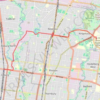
Name: Tracked with OSMTracker for Android™ trail, distance, elevation, map, profile, GPS track
Start: 146, Bell Street, Coburg, Melbourne, Victoria, 3058, Australia (-37.74098 144.96332)
Coordinates: -37.74177 144.96332 -37.71307 145.04639
Other hiking, mountain biking, running and outdoor activity trails
Click on a trail to view its statistics, map and profile.
Tracked with OSMTracker for Android™
Australia > Victoria > Melbourne
accuracy good, 2-6m
Distance: 16.9 Km • Elevation gain: 110 m • Maximum elevation: 88 m


Tallarook - Eildon - Hurstbridge
Australia > Victoria > Tallarook
#Bike
Distance: 278.8 Km • Elevation gain: 4,897 m • Maximum elevation: 868 m

Melbourne Bike Ride
Australia > Victoria > Melbourne
Distance: 45.2 Km • Elevation gain: 272 m • Maximum elevation: 111 m