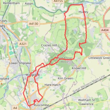
Twyford to Hurley loop
- Distance: 25.3 Km
- Elevation gain: 339 m
- Maximum elevation: 143 m
- Elevation loss: 338 m
- Minimum elevation: 28 m
- Moving time: 3 h 16 m
- Moving speed: 7.7 Km/h
- Maximum speed: 13.2 Km/h
- Total time: 3 h 28 m
- Global speed: 7.3 Km/h
Interactive trail map
Trail profile
- Distance: 25.3 Km
- Elevation gain: 339 m
- Maximum elevation: 143 m
- Elevation loss: 338 m
- Minimum elevation: 28 m
- Moving time: 3 h 16 m
- Moving speed: 7.7 Km/h
- Maximum speed: 13.2 Km/h
- Total time: 3 h 28 m
- Global speed: 7.3 Km/h
About this trail
Name: Twyford to Hurley loop trail, distance, elevation, map, profile, GPS track
Coordinates: 51.48059 -0.87652 51.55073 -0.80666
Other hiking, mountain biking, running and outdoor activity trails
Click on a trail to view its statistics, map and profile.
The Jo Cox Way 2022 Day 4 - Milton Keynes to Uxbridge
United Kingdom > England > City of Milton Keynes > Milton Keynes > Monkston
Distance: 104.4 Km • Elevation gain: 1,038 m • Maximum elevation: 251 m