Goat Island Lookout Loop
- Distance: 5.4 Km
- Elevation gain: 192 m
- Maximum elevation: 117 m
- Elevation loss: 184 m
- Minimum elevation: 5 m
- Moving time: 1 h 29 m
- Moving speed: 3.6 Km/h
- Maximum speed: 6.8 Km/h
- Total time: 1 h 42 m
- Global speed: 3.1 Km/h
Interactive trail map
Trail profile
- Distance: 5.4 Km
- Elevation gain: 192 m
- Maximum elevation: 117 m
- Elevation loss: 184 m
- Minimum elevation: 5 m
- Moving time: 1 h 29 m
- Moving speed: 3.6 Km/h
- Maximum speed: 6.8 Km/h
- Total time: 1 h 42 m
- Global speed: 3.1 Km/h
About this trail
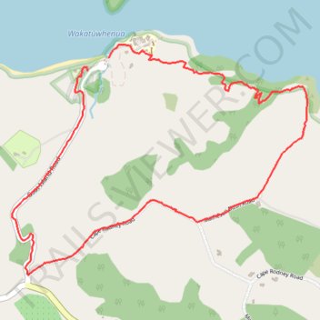
Name: Goat Island Lookout Loop trail, distance, elevation, map, profile, GPS track
Start: Goat Island Road, Leigh, Rodney, Auckland, New Zealand (-36.27007 174.79638)
End: Main Carpark, Goat Island Road, Leigh, Rodney, Auckland, New Zealand (-36.27073 174.79505)
Coordinates: -36.28096 174.79036 -36.26941 174.80872
Topography: Rodney topographic map, elevation, terrain