Thank you for supporting this site ❤️
Make a donation
Make a donation
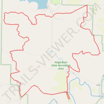
Volga River State Recreation Area Loop Hike
- Distance: 19.5 Km
- Elevation gain: 314 m
- Maximum elevation: 358 m
- Elevation loss: 314 m
- Minimum elevation: 282 m
- Moving time: 2 h 46 m
- Moving speed: 7.0 Km/h
- Maximum speed: 16.7 Km/h
- Total time: 3 h 17 m
- Global speed: 5.9 Km/h
Interactive trail map
Thank you for supporting this site ❤️
Make a donation
Make a donation
Trail profile
- Distance: 19.5 Km
- Elevation gain: 314 m
- Maximum elevation: 358 m
- Elevation loss: 314 m
- Minimum elevation: 282 m
- Moving time: 2 h 46 m
- Moving speed: 7.0 Km/h
- Maximum speed: 16.7 Km/h
- Total time: 3 h 17 m
- Global speed: 5.9 Km/h
Thank you for supporting this site ❤️
Make a donation
Make a donation
About this trail
Name: Volga River State Recreation Area Loop Hike trail, distance, elevation, map, profile, GPS track
Start: Hill Road, Albany, Fayette County, Iowa, United States (42.87100 -91.75774)
End: Hill Road, Albany, Fayette County, Iowa, 52142, United States (42.87121 -91.75781)
Coordinates: 42.86316 -91.78905 42.89698 -91.74204
Thank you for supporting this site ❤️
Make a donation
Make a donation