Tahquitz Canyon Loop Trail in Santa Rosa and San Jacinto Mountains National Monument
The Tahquitz Canyon Loop Trail offers a moderate hike through the striking desert landscape, showcasing vivid rock formations and native vegetation. As you trek through the canyon, you’ll encounter culturally significant rock art and be treated to a spectacular view of Tahquitz Falls, which cascades over the rocky cliffs. The trail, while short, provides both scenic beauty and a glimpse into the desert's unique ecosystem, with additional smaller waterfalls and shady pockets along the way. #Hiking #Canyon #Waterfall #Nature #Loop #Desert #Rock
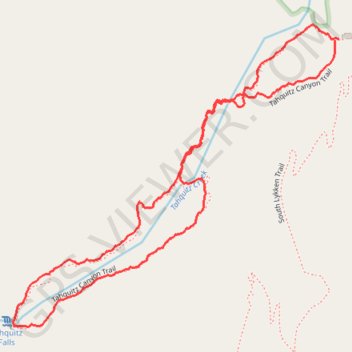
- Distance: 2.8 Km
- Elevation gain: 119 m
- Maximum elevation: 279 m
- Elevation loss: 118 m
- Minimum elevation: 178 m
- Moving time: 1 h 10 m
- Moving speed: 2.3 Km/h
- Maximum speed: 4.2 Km/h
- Total time: 1 h 30 m
- Global speed: 1.8 Km/h
Interactive trail map
Trail profile
- Distance: 2.8 Km
- Elevation gain: 119 m
- Maximum elevation: 279 m
- Elevation loss: 118 m
- Minimum elevation: 178 m
- Moving time: 1 h 10 m
- Moving speed: 2.3 Km/h
- Maximum speed: 4.2 Km/h
- Total time: 1 h 30 m
- Global speed: 1.8 Km/h
About this trail
Name: Tahquitz Canyon Loop Trail in Santa Rosa and San Jacinto Mountains National Monument trail, distance, elevation, map, profile, GPS track
Coordinates: 33.80351 -116.56178 33.81025 -116.55304
Other hiking, mountain biking, running and outdoor activity trails
Click on a trail to view its statistics, map and profile.
Cactus to Clouds
United States > California > Riverside County > Palm Springs
Hike from Palm Springs to San Jacinto Peak by the Skyline Trail, the Grubbs Notch, the Round Valley Trail, the Wellman Divide and the Peak Trail in the Santa Rosa and San Jacinto Mountains National Monument. #Hiking #Mountain #Nature #Forest #Park
Distance: 31.6 Km • Elevation gain: 3,298 m • Maximum elevation: 3,280 m