Thank you for supporting this site ❤️
Make a donation
Make a donation
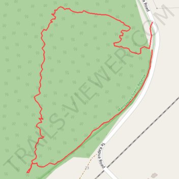
Mangaweka Scenic Track
- Distance: 1.6 Km
- Elevation gain: 80 m
- Maximum elevation: 426 m
- Elevation loss: 81 m
- Minimum elevation: 350 m
- Moving time: 27 m 14 s
- Moving speed: 3.5 Km/h
- Maximum speed: 9.9 Km/h
- Total time: 29 m 47 s
- Global speed: 3.2 Km/h
Interactive trail map
Thank you for supporting this site ❤️
Make a donation
Make a donation
Trail profile
- Distance: 1.6 Km
- Elevation gain: 80 m
- Maximum elevation: 426 m
- Elevation loss: 81 m
- Minimum elevation: 350 m
- Moving time: 27 m 14 s
- Moving speed: 3.5 Km/h
- Maximum speed: 9.9 Km/h
- Total time: 29 m 47 s
- Global speed: 3.2 Km/h
Thank you for supporting this site ❤️
Make a donation
Make a donation
About this trail
Name: Mangaweka Scenic Track trail, distance, elevation, map, profile, GPS track
Coordinates: -39.81239 175.78001 -39.80853 175.78381
Topography: Rangitīkei District topographic map, elevation, terrain
Thank you for supporting this site ❤️
Make a donation
Make a donation