Palgrave Trail
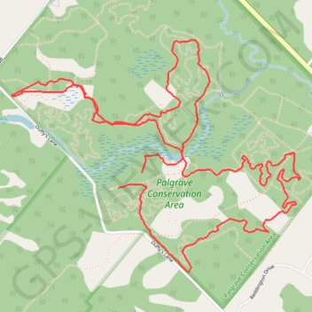
Interactive trail map
Trail profile
- Distance: 8.2 Km
- Elevation gain: 74 m
- Maximum elevation: 301 m
- Elevation loss: 69 m
- Minimum elevation: 278 m
About this trail
Name: Palgrave Trail trail, distance, elevation, map, profile, GPS track
Start: Duffy's Lane, Caledon, Peel Region, Golden Horseshoe, Ontario, L7E 0M1, Canada (43.95186 -79.85705)
End: Duffy's Lane, Caledon, Peel Region, Golden Horseshoe, Ontario, L7E 0M1, Canada (43.95109 -79.85868)
Coordinates: 43.94693 -79.86602 43.95842 -79.84617
Other hiking, mountain biking, running and outdoor activity trails
Click on a trail to view its statistics, map and profile.
Ontario country roads
Distance: 150.4 Km • Elevation gain: 1,137 m • Maximum elevation: 497 m