Thank you for supporting this site ❤️
Make a donation
Make a donation
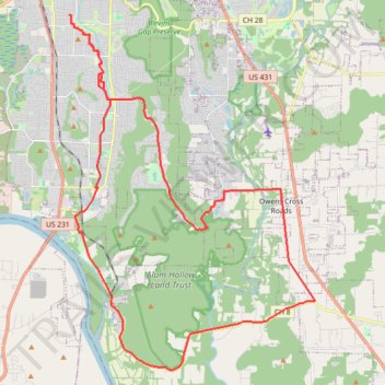
Morning Ride
- Distance: 50.5 Km
- Elevation gain: 534 m
- Maximum elevation: 445 m
- Elevation loss: 522 m
- Minimum elevation: 171 m
- Moving time: 2 h 35 m
- Moving speed: 19.5 Km/h
- Maximum speed: 48.5 Km/h
- Total time: 2 h 49 m
- Global speed: 17.9 Km/h
Interactive trail map
Thank you for supporting this site ❤️
Make a donation
Make a donation
Trail profile
- Distance: 50.5 Km
- Elevation gain: 534 m
- Maximum elevation: 445 m
- Elevation loss: 522 m
- Minimum elevation: 171 m
- Moving time: 2 h 35 m
- Moving speed: 19.5 Km/h
- Maximum speed: 48.5 Km/h
- Total time: 2 h 49 m
- Global speed: 17.9 Km/h
Thank you for supporting this site ❤️
Make a donation
Make a donation
About this trail
Name: Morning Ride trail, distance, elevation, map, profile, GPS track
Coordinates: 34.52392 -86.55839 34.66215 -86.44285
Thank you for supporting this site ❤️
Make a donation
Make a donation
Other hiking, mountain biking, running and outdoor activity trails
Click on a trail to view its statistics, map and profile.
Goldsmith-Shiffman Wildlife Sanctuary Loop
United States > Alabama > Madison County > Huntsville
Distance: 5.9 Km • Elevation gain: 14 m • Maximum elevation: 182 m
Fanning Trail in Blevins Gap Preserve
United States > Alabama > Madison County > Huntsville > Huntsville Hills
Distance: 8.6 Km • Elevation gain: 290 m • Maximum elevation: 409 m
Blevins Gap Nature Preserve loop
United States > Alabama > Madison County > Huntsville > Ridgewood
Distance: 13.3 Km • Elevation gain: 433 m • Maximum elevation: 458 m
Jones Valley Loop, Bailey Cove, Fanning, Scout, and in-progress Bailey Cove extension trails
United States > Alabama > Madison County > Huntsville > Huntsville Hills
Distance: 11.9 Km • Elevation gain: 379 m • Maximum elevation: 420 m
Thank you for supporting this site ❤️
Make a donation
Make a donation