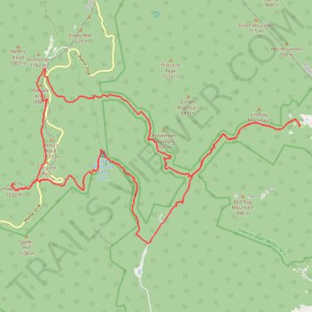
Loop hike via Weakley Hollow, White Oak Canyon, Hawksbill, Appalachian Trailand Old Rag in Shenandoah National Park
- Distance: 35.1 Km
- Elevation gain: 1,446 m
- Maximum elevation: 1,217 m
- Elevation loss: 1,448 m
- Minimum elevation: 283 m
- Moving time: 3 h 54 m
- Moving speed: 9.0 Km/h
- Maximum speed: 16.1 Km/h
- Total time: 3 h 58 m
- Global speed: 8.8 Km/h
Interactive trail map
Trail profile
- Distance: 35.1 Km
- Elevation gain: 1,446 m
- Maximum elevation: 1,217 m
- Elevation loss: 1,448 m
- Minimum elevation: 283 m
- Moving time: 3 h 54 m
- Moving speed: 9.0 Km/h
- Maximum speed: 16.1 Km/h
- Total time: 3 h 58 m
- Global speed: 8.8 Km/h
About this trail
Name: Loop hike via Weakley Hollow, White Oak Canyon, Hawksbill, Appalachian Trailand Old Rag in Shenandoah National Park trail, distance, elevation, map, profile, GPS track
Start: Old Rag Lower Lot, Ridge trail, Madison County, Virginia, 22719, United States (38.57092 -78.29391)
End: Old Rag Lower Lot, Ridge trail, Madison County, Virginia, 22719, United States (38.57097 -78.29373)
Coordinates: 38.53838 -78.39601 38.58735 -78.29373
Other hiking, mountain biking, running and outdoor activity trails
Click on a trail to view its statistics, map and profile.
Hawksbill Trail in Shenandoah National Park
United States > Virginia > Madison County
Hiking the Hawksbill Trail is a truly rewarding experience, leading you through lush forests to the summit of Shenandoah National Park's highest peak. Along the way, you’ll encounter stunning views of the Shenandoah Valley and the majestic Blue Ridge Mountains, especially from the rocky outcrops and the…
Distance: 2.7 Km • Elevation gain: 194 m • Maximum elevation: 1,217 m
Old Rag Mountain Loop via Ridge Trail, saddle Trail and Weakley Hollow Fire Road
United States > Virginia > Madison County > Nethers
The Old Rag Mountain Loop offers one of the most iconic and challenging hiking experiences in Shenandoah National Park, featuring rocky scrambles, expansive views, and a rewarding sense of accomplishment. Hikers are treated to panoramic vistas from the summit, where the rugged Blue Ridge Mountains unfold in…
Distance: 14.6 Km • Elevation gain: 753 m • Maximum elevation: 990 m
Hawksbill Loop Trail via Appalachian Trail in Shenandoah National Park
United States > Virginia > Madison County
The Hawksbill Loop Trail in Shenandoah National Park offers hikers a journey through lush forests and rocky terrains, culminating at the park's highest peak, Hawksbill Summit. From the summit's viewing platform, one can enjoy panoramic vistas of the Shenandoah Valley, the Blue Ridge Mountains, and the Virginia…
Distance: 4.4 Km • Elevation gain: 223 m • Maximum elevation: 1,217 m
Loop hike to Hawksbill via Appalachian Trail in Shenandoah National Park
United States > Virginia > Madison County
Hiking the Hawksbill is an exhilarating experience, where you’re rewarded with breathtaking 360-degree views from the summit, showcasing the vastness of the Shenandoah Valley and the Blue Ridge Mountains. Along the trail, you'll encounter vibrant wildflowers, rocky outcrops, and the occasional glimpse of…
Distance: 4.6 Km • Elevation gain: 221 m • Maximum elevation: 1,217 m
Hawksbill Summit via Lower Hawksbill Trail in Shenandoah National Park
United States > Virginia > Madison County
The hike to Hawksbill Summit via the Lower Hawksbill Trail is a moderately challenging hike through a lush, forested path that eventually opens up to stunning panoramic views from the highest peak in Shenandoah National Park. Along the route, hikers navigate rocky terrain, pass through shaded woodlands lined…
Distance: 2.6 Km • Elevation gain: 190 m • Maximum elevation: 1,217 m
Old Rag Mountain Loop Trail in Shenandoah National Park
United States > Virginia > Madison County
The Old Rag Mountain Loop Trail is a thrilling hike known for its mix of intense rock scrambles and panoramic views from the summit. Starting with a steep ascent, the Ridge Trail leads you through some fun yet challenging rock formations, requiring both hands and feet for maneuvering. Once you reach the…
Distance: 14.9 Km • Elevation gain: 818 m • Maximum elevation: 991 m