Thank you for supporting this site ❤️
Make a donation
Make a donation
2023-05-07_09-06_Sun
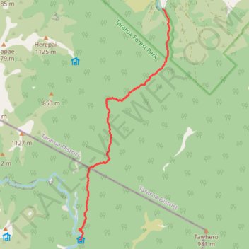
- Distance: 8.2 Km
- Elevation gain: 366 m
- Maximum elevation: 750 m
- Elevation loss: 454 m
- Minimum elevation: 340 m
- Moving time: 2 h 58 m
- Moving speed: 2.8 Km/h
- Maximum speed: 7.3 Km/h
- Total time: 4 h 18 m
- Global speed: 1.9 Km/h
Interactive trail map
Thank you for supporting this site ❤️
Make a donation
Make a donation
Trail profile
- Distance: 8.2 Km
- Elevation gain: 366 m
- Maximum elevation: 750 m
- Elevation loss: 454 m
- Minimum elevation: 340 m
- Moving time: 2 h 58 m
- Moving speed: 2.8 Km/h
- Maximum speed: 7.3 Km/h
- Total time: 4 h 18 m
- Global speed: 1.9 Km/h
Thank you for supporting this site ❤️
Make a donation
Make a donation
About this trail
Name: 2023-05-07_09-06_Sun trail, distance, elevation, map, profile, GPS track
Start: Roaring Stag Hut, Masterton, Wellington, New Zealand (-40.73061 175.52443)
End: Putara Road, Tararua District, Manawatū-Whanganui, New Zealand (-40.68100 175.54802)
Coordinates: -40.73069 175.52422 -40.68100 175.54998
Topography: Wellington topographic map, elevation, terrain
Thank you for supporting this site ❤️
Make a donation
Make a donation
Other hiking, mountain biking, running and outdoor activity trails
Click on a trail to view its statistics, map and profile.
2023-05-06_14-54_Sat
New Zealand > Manawatū-Whanganui > Tararua District
Distance: 8.1 Km • Elevation gain: 439 m • Maximum elevation: 750 m