Thank you for supporting this site ❤️
Make a donation
Make a donation
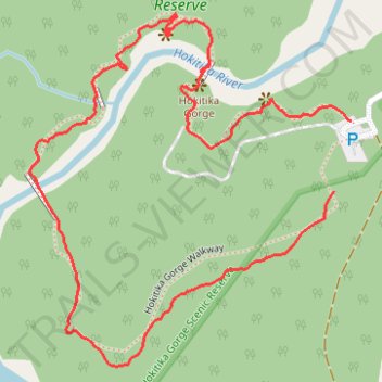
Hokitika Gorge Walkway
- Distance: 2.2 Km
- Elevation gain: 63 m
- Maximum elevation: 115 m
- Elevation loss: 53 m
- Minimum elevation: 83 m
- Moving time: 35 m 17 s
- Moving speed: 3.7 Km/h
- Maximum speed: 8.2 Km/h
- Total time: 44 m 24 s
- Global speed: 2.9 Km/h
Interactive trail map
Thank you for supporting this site ❤️
Make a donation
Make a donation
Trail profile
- Distance: 2.2 Km
- Elevation gain: 63 m
- Maximum elevation: 115 m
- Elevation loss: 53 m
- Minimum elevation: 83 m
- Moving time: 35 m 17 s
- Moving speed: 3.7 Km/h
- Maximum speed: 8.2 Km/h
- Total time: 44 m 24 s
- Global speed: 2.9 Km/h
Thank you for supporting this site ❤️
Make a donation
Make a donation
About this trail
Name: Hokitika Gorge Walkway trail, distance, elevation, map, profile, GPS track
Start: Hokitika Gorge Walk, Westland District, West Coast, New Zealand (-42.95632 171.01967)
End: Hokitika Gorge Walkway, Westland District, West Coast, New Zealand (-42.95737 171.01932)
Coordinates: -42.95998 171.01314 -42.95473 171.01967
Topography: Westland District topographic map, elevation, terrain
Thank you for supporting this site ❤️
Make a donation
Make a donation
Other hiking, mountain biking, running and outdoor activity trails
Click on a trail to view its statistics, map and profile.