Thank you for supporting this site ❤️
Make a donation
Make a donation
2026-04-24 11:59:37
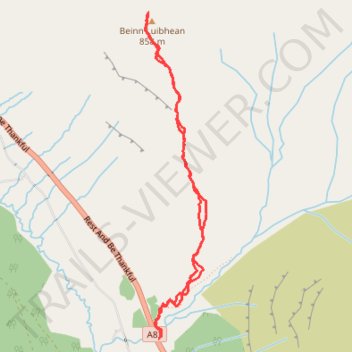
- Distance: 5.0 Km
- Elevation gain: 686 m
- Maximum elevation: 849 m
- Elevation loss: 684 m
- Minimum elevation: 163 m
- Moving time: 2 h 38 m
- Moving speed: 1.9 Km/h
- Maximum speed: 4.9 Km/h
- Total time: 3 h 29 m
- Global speed: 1.4 Km/h
Interactive trail map
Thank you for supporting this site ❤️
Make a donation
Make a donation
Trail profile
- Distance: 5.0 Km
- Elevation gain: 686 m
- Maximum elevation: 849 m
- Elevation loss: 684 m
- Minimum elevation: 163 m
- Moving time: 2 h 38 m
- Moving speed: 1.9 Km/h
- Maximum speed: 4.9 Km/h
- Total time: 3 h 29 m
- Global speed: 1.4 Km/h
Thank you for supporting this site ❤️
Make a donation
Make a donation
About this trail
Name: 2026-04-24 11:59:37 trail, distance, elevation, map, profile, GPS track
Start: Rest And Be Thankful, Argyll and Bute, Scotland, G83 7AS, United Kingdom (56.21397 -4.83525)
End: Rest And Be Thankful, Argyll and Bute, Scotland, G83 7AS, United Kingdom (56.21409 -4.83519)
Coordinates: 56.21397 -4.83658 56.23136 -4.83065
Thank you for supporting this site ❤️
Make a donation
Make a donation
Other hiking, mountain biking, running and outdoor activity trails
Click on a trail to view its statistics, map and profile.