Thank you for supporting this site ❤️
Make a donation
Make a donation
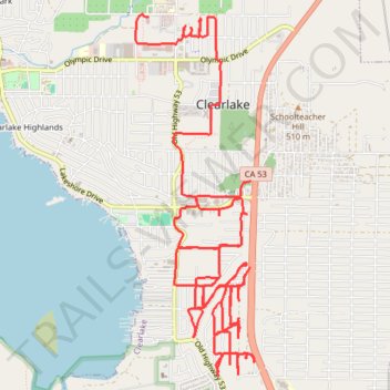
2026-04-23_13-59_Thu
- Distance: 19.0 Km
- Elevation gain: 224 m
- Maximum elevation: 445 m
- Elevation loss: 253 m
- Minimum elevation: 411 m
- Moving time: 1 h 5 m
- Moving speed: 17.3 Km/h
- Maximum speed: 44.0 Km/h
- Total time: 1 h 11 m
- Global speed: 16.0 Km/h
Interactive trail map
Thank you for supporting this site ❤️
Make a donation
Make a donation
Trail profile
- Distance: 19.0 Km
- Elevation gain: 224 m
- Maximum elevation: 445 m
- Elevation loss: 253 m
- Minimum elevation: 411 m
- Moving time: 1 h 5 m
- Moving speed: 17.3 Km/h
- Maximum speed: 44.0 Km/h
- Total time: 1 h 11 m
- Global speed: 16.0 Km/h
Thank you for supporting this site ❤️
Make a donation
Make a donation
About this trail
Name: 2026-04-23_13-59_Thu trail, distance, elevation, map, profile, GPS track
Start: CA 53, Clearlake, Lake County, California, 95422, United States (38.95201 -122.62352)
Coordinates: 38.93634 -122.63546 38.96544 -122.62302
Thank you for supporting this site ❤️
Make a donation
Make a donation