Hailes Cave Lot to Overlook via the Escarpment Trail
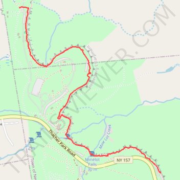
From Hailes Cave Lot, the route follows the Escarpment Trail along the wooded rim of John Boyd Thacher State Park, passing the Hailes Cave area and the Squeeze Box rock-climbing entrance above the Helderberg Escarpment.
It continues south past Horseshoe and the Indian Ladder area, where limestone cliffs, fossil-rich rock, seasonal falls, and the forested edge of Minelot Creek shape the landscape.
The hike finishes at the Overlook, opening onto broad views across the Hudson-Mohawk Valleys toward distant mountain ranges.
#Hiking #Park #Escarpment #Overlook #Forest #Cliffs #Nature
- Distance: 3.2 Km
- Elevation gain: 98 m
- Maximum elevation: 367 m
- Elevation loss: 127 m
- Minimum elevation: 319 m
- Moving time: 38 m 54 s
- Moving speed: 4.9 Km/h
- Maximum speed: 9.7 Km/h
- Total time: 46 m 51 s
- Global speed: 4.1 Km/h
Interactive trail map
Trail profile
- Distance: 3.2 Km
- Elevation gain: 98 m
- Maximum elevation: 367 m
- Elevation loss: 127 m
- Minimum elevation: 319 m
- Moving time: 38 m 54 s
- Moving speed: 4.9 Km/h
- Maximum speed: 9.7 Km/h
- Total time: 46 m 51 s
- Global speed: 4.1 Km/h
About this trail
Name: Hailes Cave Lot to Overlook via the Escarpment Trail trail, distance, elevation, map, profile, GPS track
Coordinates: 42.65117 -74.02137 42.66394 -74.00660
Other hiking, mountain biking, running and outdoor activity trails
Click on a trail to view its statistics, map and profile.