Thank you for supporting this site ❤️
Make a donation
Make a donation
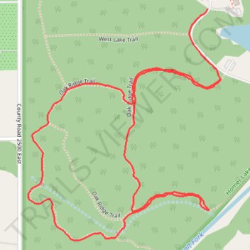
Oak Ridge Trail in Homer Lake Forest Preserve
- Distance: 2.9 Km
- Elevation gain: 19 m
- Maximum elevation: 203 m
- Elevation loss: 18 m
- Minimum elevation: 192 m
- Moving time: 48 m 7 s
- Moving speed: 3.7 Km/h
- Maximum speed: 6.0 Km/h
- Total time: 57 m 1 s
- Global speed: 3.1 Km/h
Interactive trail map
Thank you for supporting this site ❤️
Make a donation
Make a donation
Trail profile
- Distance: 2.9 Km
- Elevation gain: 19 m
- Maximum elevation: 203 m
- Elevation loss: 18 m
- Minimum elevation: 192 m
- Moving time: 48 m 7 s
- Moving speed: 3.7 Km/h
- Maximum speed: 6.0 Km/h
- Total time: 57 m 1 s
- Global speed: 3.1 Km/h
Thank you for supporting this site ❤️
Make a donation
Make a donation
About this trail
Name: Oak Ridge Trail in Homer Lake Forest Preserve trail, distance, elevation, map, profile, GPS track
Start: West Lake Trail, Champaign County, Illinois, 61849, United States (40.06138 -87.98803)
End: Oak Ridge Trail, Champaign County, Illinois, 61849, United States (40.05952 -87.98755)
Coordinates: 40.05528 -87.99421 40.06138 -87.98755
Thank you for supporting this site ❤️
Make a donation
Make a donation