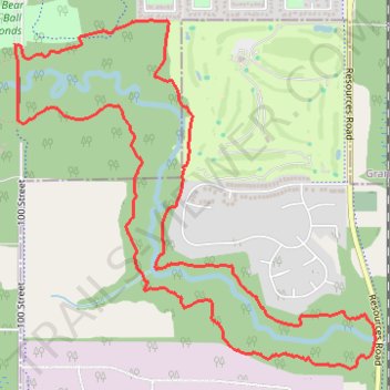
Wedgewood Loop
- Distance: 7.5 Km
- Elevation gain: 108 m
- Maximum elevation: 654 m
- Elevation loss: 107 m
- Minimum elevation: 628 m
- Moving time: 1 h 3 m
- Moving speed: 7.0 Km/h
- Maximum speed: 10.2 Km/h
- Total time: 1 h 3 m
- Global speed: 7.0 Km/h
Interactive trail map
Trail profile
- Distance: 7.5 Km
- Elevation gain: 108 m
- Maximum elevation: 654 m
- Elevation loss: 107 m
- Minimum elevation: 628 m
- Moving time: 1 h 3 m
- Moving speed: 7.0 Km/h
- Maximum speed: 10.2 Km/h
- Total time: 1 h 3 m
- Global speed: 7.0 Km/h
About this trail
Name: Wedgewood Loop trail, distance, elevation, map, profile, GPS track
Start: Outter Waxwing, Grande Prairie, Alberta, T8W 0H1, Canada (55.13328 -118.79509)
End: Outter Waxwing, Grande Prairie, Alberta, T8W 0H1, Canada (55.13333 -118.79538)
Coordinates: 55.11854 -118.79538 55.13438 -118.76671