Thank you for supporting this site ❤️
Make a donation
Make a donation
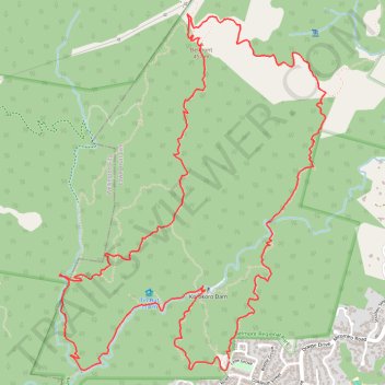
Belmont Trig loop walk
- Distance: 11.0 Km
- Elevation gain: 609 m
- Maximum elevation: 446 m
- Elevation loss: 610 m
- Minimum elevation: 62 m
- Moving time: 2 h 34 m
- Moving speed: 4.3 Km/h
- Maximum speed: 7.9 Km/h
- Total time: 3 h 19 m
- Global speed: 3.3 Km/h
Interactive trail map
Thank you for supporting this site ❤️
Make a donation
Make a donation
Trail profile
- Distance: 11.0 Km
- Elevation gain: 609 m
- Maximum elevation: 446 m
- Elevation loss: 610 m
- Minimum elevation: 62 m
- Moving time: 2 h 34 m
- Moving speed: 4.3 Km/h
- Maximum speed: 7.9 Km/h
- Total time: 3 h 19 m
- Global speed: 3.3 Km/h
Thank you for supporting this site ❤️
Make a donation
Make a donation
About this trail
Name: Belmont Trig loop walk trail, distance, elevation, map, profile, GPS track
Coordinates: -41.20238 174.86309 -41.18170 174.88363
Topography: Lower Hutt topographic map, elevation, terrain
Thank you for supporting this site ❤️
Make a donation
Make a donation
Other hiking, mountain biking, running and outdoor activity trails
Click on a trail to view its statistics, map and profile.
Korokoro Dam
New Zealand > Wellington > Lower Hutt City > Lower Hutt
Walking
Distance: 3.0 Km • Elevation gain: 156 m • Maximum elevation: 201 m
2023-12-27_11-33_Wed
New Zealand > Wellington > Lower Hutt City > Lower Hutt
Distance: 10.6 Km • Elevation gain: 514 m • Maximum elevation: 446 m