Godley Head Walkway, Awaroa-Godley Head Loop Track and Crater Rim Walkway hike
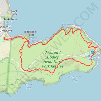
- Distance: 8.9 Km
- Elevation gain: 418 m
- Maximum elevation: 204 m
- Elevation loss: 418 m
- Minimum elevation: 5 m
- Moving time: 2 h 23 m
- Moving speed: 3.7 Km/h
- Maximum speed: 5.1 Km/h
- Total time: 2 h 32 m
- Global speed: 3.5 Km/h
Interactive trail map
Trail profile
- Distance: 8.9 Km
- Elevation gain: 418 m
- Maximum elevation: 204 m
- Elevation loss: 418 m
- Minimum elevation: 5 m
- Moving time: 2 h 23 m
- Moving speed: 3.7 Km/h
- Maximum speed: 5.1 Km/h
- Total time: 2 h 32 m
- Global speed: 3.5 Km/h
About this trail
Name: Godley Head Walkway, Awaroa-Godley Head Loop Track and Crater Rim Walkway hike trail, distance, elevation, map, profile, GPS track
Coordinates: -43.59300 172.77575 -43.58208 172.80701
Topography: Christchurch topographic map, elevation, terrain
Other hiking, mountain biking, running and outdoor activity trails
Click on a trail to view its statistics, map and profile.