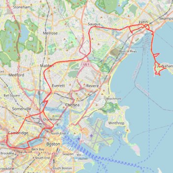
Nahant and Northern Strand Trail
- Distance: 70.3 Km
- Elevation gain: 388 m
- Maximum elevation: 23 m
- Elevation loss: 383 m
- Minimum elevation: -2 m
- Moving time: 4 h 24 s
- Moving speed: 17.6 Km/h
- Maximum speed: 42.0 Km/h
- Total time: 5 h 43 m
- Global speed: 12.3 Km/h
Interactive trail map
Trail profile
- Distance: 70.3 Km
- Elevation gain: 388 m
- Maximum elevation: 23 m
- Elevation loss: 383 m
- Minimum elevation: -2 m
- Moving time: 4 h 24 s
- Moving speed: 17.6 Km/h
- Maximum speed: 42.0 Km/h
- Total time: 5 h 43 m
- Global speed: 12.3 Km/h
About this trail
Name: Nahant and Northern Strand Trail trail, distance, elevation, map, profile, GPS track
Coordinates: 42.35082 -71.11823 42.46439 -70.92075
Other hiking, mountain biking, running and outdoor activity trails
Click on a trail to view its statistics, map and profile.
Skyline and Reservoir Loop Trail in Middlesex Fells Reservation
United States > Massachusetts > Middlesex County > Medford
The Skyline and Reservoir Loop Trail offers a moderately challenging experience with rugged terrain, rewarding hikers with sweeping views of the Boston skyline. As the trail winds through forested sections and around scenic reservoirs, it also climbs to rocky summits, providing natural vantage points. This…
Distance: 12.9 Km • Elevation gain: 167 m • Maximum elevation: 79 m
Rock Circuit Loop Trail via Boojum Rock, Ziggy's Rock, Pinnacle Rock, Black Rock and Melrose Rock in Middlesex Fells Reservation
United States > Massachusetts > Middlesex County > Medford
The Rock Circuit Loop Trail is a captivating route that showcases a variety of unique rock formations and stunning vistas. Hikers will experience the impressive sights from Boojum Rock and Melrose Rock, where expansive views of Boston and the surrounding area can be enjoyed. The trail combines challenging…
Distance: 7.4 Km • Elevation gain: 102 m • Maximum elevation: 83 m
Boston's Freedom Trail
United States > Massachusetts > Suffolk County > Boston
Walking Boston's Freedom Trail offers a seamless journey through America’s Revolutionary history, with a lively path marked by historic buildings and memorials, from the lush Boston Common to the monumental Bunker Hill. Each stop, such as the Old South Meeting House and Faneuil Hall, is packed with stories…
Distance: 3.8 Km • Elevation gain: 63 m • Maximum elevation: 38 m
Charles River Trails in Watertown, Newton, Cambridge, Boston
United States > Massachusetts > Middlesex County > Newton
River Ride, both sides
Distance: 26.4 Km • Elevation gain: 166 m • Maximum elevation: 14 m
The Trails of Groton with 3k Dirt in Lincoln/Lexington (Arlington Start)
United States > Massachusetts > Middlesex County > Arlington
Distance: 111.4 Km • Elevation gain: 1,034 m • Maximum elevation: 109 m
2024 Bikes Not Bombs Bike-a-thon (BAT) Agony & Ecstasy
United States > Massachusetts > Suffolk County > Boston
Distance: 171.3 Km • Elevation gain: 1,714 m • Maximum elevation: 183 m
Gravel Bike Sennot Park
United States > Massachusetts > Middlesex County > Cambridge
Distance: 4.4 Km • Elevation gain: 16 m • Maximum elevation: 11 m
GravelBike_20Miles
United States > Massachusetts > Suffolk County > Boston
Evening Ride
Distance: 35.4 Km • Elevation gain: 249 m • Maximum elevation: 33 m
BELLEVUE
United States > Massachusetts > Middlesex County > Medford
Bike Loop Bellevue
Distance: 11.2 Km • Elevation gain: 126 m • Maximum elevation: 88 m
Gravel Bike City Square Park
United States > Massachusetts > Suffolk County > Boston
Distance: 2.2 Km • Elevation gain: 8 m • Maximum elevation: 12 m